Szarvaskő
- Szarvaskő
-
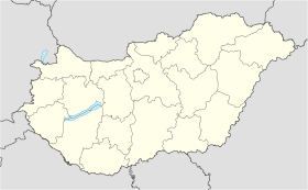
Szarvaskő est un village et une commune du comitat de Heves en Hongrie.
Géographie
Cette section est vide, insuffisamment détaillée ou incomplète.
Votre aide est la bienvenue !
Histoire
Cette section est vide, insuffisamment détaillée ou incomplète.
Votre aide est la bienvenue !
Catégorie :
- Ville et village du comitat de Heves
Wikimedia Foundation.
2010.
Contenu soumis à la licence CC-BY-SA. Source : Article Szarvaskő de Wikipédia en français (auteurs)
Regardez d'autres dictionnaires:
Countrywide Blue Tour in Hungary — The route of the Countrywide Blue Tour in Hungary The Countrywide Blue Tour (in Hungarian: Országos Kéktúra, Kéktúra or simply OKT) is a part of the Hungarian section of the European Long Distance Walking Route E4. The route starts atop the… … Wikipedia
Öko-Park® Panzió-Kemping és Kalandpark — (Szarvaskő,Венгрия) Категория отеля: 3 звездочный отель Адрес … Каталог отелей
Heves County — Infobox Hungarian county name =Heves region =Northern Hungary seat = Eger area = 3637 population = 328,000 density = 90.1 cities = 119 This article is about the current administrative entity called Heves county. For the historical county see… … Wikipedia
Döbrönte — Döbrönte … Wikipedia
Hunveyor Husar planetary analog field trips — The Hunveyor (Hungarian UNiversity SURVEYOR) and Husar rover (Hungarian University Surface Analyser Rover) acronyms mark the educational planetary robot system of the Hungarian universities, colleges, high schools. Such systems are built by… … Wikipedia
European walking route E4 — is one of the European long distance paths starting in Spain at its southernmost point and leading through France, Switzerland, Germany, Austria, Hungary, Romania and Bulgaria to end in Greece. It visits the Greek islands of Crete and Cyprus.Its… … Wikipedia
Mónosbél — Municipality … Wikipedia
Balvany — Bükk Lage des Bükks im Norden Ungarns zwischen Eger und Miskolc … Deutsch Wikipedia
Bálvány — Bükk Lage des Bükks im Norden Ungarns zwischen Eger und Miskolc … Deutsch Wikipedia
Bükk — Lage des Bükks im Norden Ungarns zwischen Eger und Miskolc … Deutsch Wikipedia


 Hongrie

 Szarvaskő


