Rózsaszentmárton
- Rózsaszentmárton
-
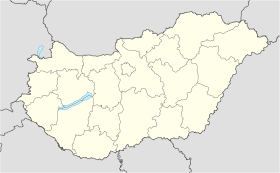
Rózsaszentmárton est un village et une commune du comitat de Heves en Hongrie.
Géographie
Cette section est vide, insuffisamment détaillée ou incomplète.
Votre aide est la bienvenue !
Histoire
Cette section est vide, insuffisamment détaillée ou incomplète.
Votre aide est la bienvenue !
Catégorie :
- Ville et village du comitat de Heves
Wikimedia Foundation.
2010.
Contenu soumis à la licence CC-BY-SA. Source : Article Rózsaszentmárton de Wikipédia en français (auteurs)
Regardez d'autres dictionnaires:
Rozsaszentmarton — Original name in latin Rzsaszentmrton Name in other language State code HU Continent/City Europe/Budapest longitude 47.782 latitude 19.7421 altitude 177 Population 2028 Date 2011 04 19 … Cities with a population over 1000 database
Heves County — Infobox Hungarian county name =Heves region =Northern Hungary seat = Eger area = 3637 population = 328,000 density = 90.1 cities = 119 This article is about the current administrative entity called Heves county. For the historical county see… … Wikipedia
Petőfibánya — (formerly Pernyepuszta, Pernyebánya) is a village in Hungary, Heves county, near Hatvan. It has a population of 3118 (2002).GeographyPetőfibánya is situated 15 km from Hatvan, in the Mátraalja microregion, among the foothills of the Mátra… … Wikipedia
Mónosbél — Municipality … Wikipedia
Kleingebiet Hatvan — Das Kleingebiet Hatvan (ungarisch hatvani kistérség) ist eine ungarische Verwaltungseinheit (LAU 1) innerhalb des Komitats Heves. Der Verwaltungssitz ist in Hatvan. Gemeinden Apc Boldog Csány Ecséd Hatvan Heréd Hort Kerekharaszt Lőrinci… … Deutsch Wikipedia
Eger (Hongrie) — Pour les articles homonymes, voir Eger. Eger Héraldique … Wikipédia en Français
Gyöngyös — Héraldique Église baroque Szent Bertala … Wikipédia en Français
Heves — 47°50′N 20°15′E / 47.833, 20.25 … Wikipédia en Français
List of populated places in Hungary — This is a list of cities, towns and villages of Hungary Contents 1 A, Á 2 B 3 C … Wikipedia
Maklár — Municipality Coat of arms … Wikipedia


 Hongrie

 Rózsaszentmárton


