Szomor
- Szomor
-
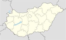
Szomor est un village et une commune du comitat de Komárom-Esztergom en Hongrie.
Géographie
Cette section est vide, insuffisamment détaillée ou incomplète.
Votre aide est la bienvenue !
Histoire
Cette section est vide, insuffisamment détaillée ou incomplète.
Votre aide est la bienvenue !
Catégorie :
- Ville et village du comitat de Komárom-Esztergom
Wikimedia Foundation.
2010.
Contenu soumis à la licence CC-BY-SA. Source : Article Szomor de Wikipédia en français (auteurs)
Regardez d'autres dictionnaires:
Szomor — Infobox Settlement subdivision type = Country subdivision name = HUN timezone=CET utc offset=+1 timezone DST=CEST utc offset DST=+2|official name=Szomor subdivision type1=County subdivision name1=Komárom Esztergom area total km2=13.19 population… … Wikipedia
Cseszneky — During the centuries the family hold several noble titles (Latin: preadicatum , Hungarian: nemesi előnév ) after their lordships, among them: de Cseszneg , de Enese , de Csécsény , de Kisbabot , de Szentkáta , de Kisbudafa , de Tejfalu , de… … Wikipedia
Tendinitis — Infobox Disease Name = Tendinitis Caption = |n bnc DiseasesDB = 31624 ICD10 = ICD10|M|77|9|m|70 ICD9 = ICD9|726.90 ICDO = OMIM = MedlinePlus = eMedicineSubj = emerg eMedicineTopic = 570 MeshID = D052256 Tendinitis or tendonitis (from the Greek… … Wikipedia
Komárom-Esztergom County — Infobox Hungarian county name =Komárom Esztergom region =Central Transdanubia seat = Tatabánya area = 2265 population = 319,000 density = 142 cities = 76Komárom Esztergom is the name of an administrative county (comitatus or megye) in northern… … Wikipedia
Tatabánya — Infobox Settlement image caption = County hall image shield = Tatabánya címere új.jpg subdivision type = Country subdivision name = HUN timezone=CET utc offset=+1 timezone DST=CEST utc offset DST=+2 pushpin pushpin label position = pushpin map… … Wikipedia
Oroszlány — Aerial view … Wikipedia
Dorog — Town … Wikipedia
Nyergesújfalu — Nyergesújfalu … Wikipedia
Jakab Cseszneky — Baron Jakab Cseszneky de Cseszneg et Visk was a Hungarian aristocrat in 13th century.Jakab was the son of Mihály , member of the clan Bána, and equerry of Andrew II of Hungary.He became the swordbearer of the King Béla IV and held also the title… … Wikipedia
HU-TB — Tatabánya Landkarte Stadtwappen Basisdaten Staa … Deutsch Wikipedia


 Hongrie

 Szomor


